- Entry
- 014
- Source scale
- 1:24,000
- Method
- Field measurement and compilation
- Section
- Hydrography
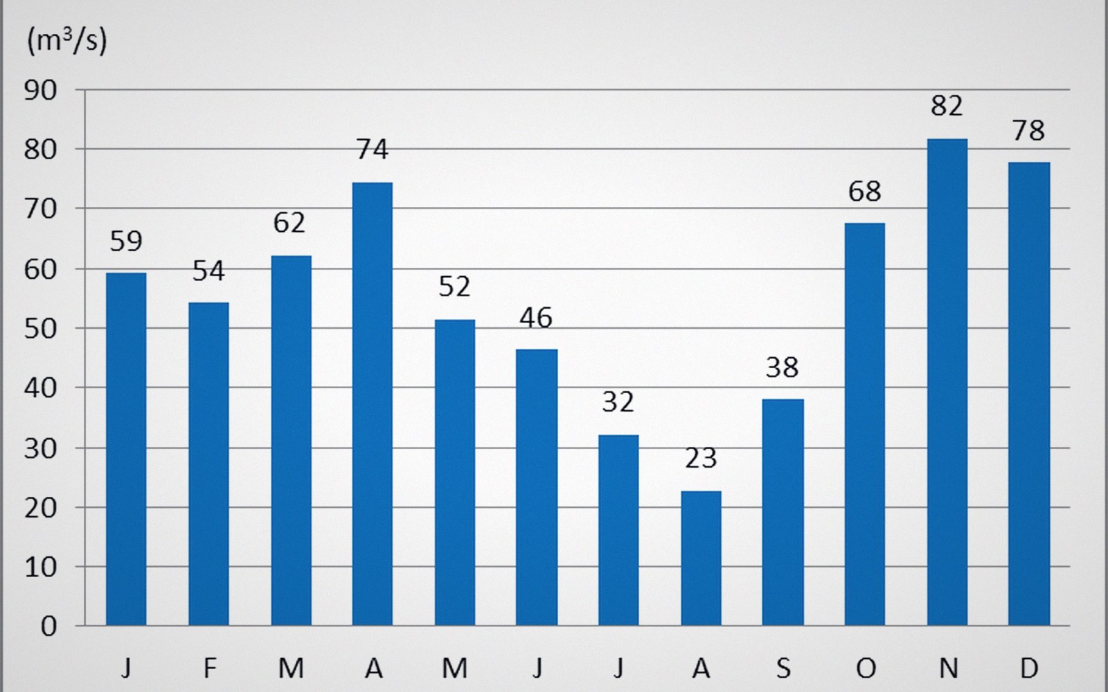
Mean stage is a level the river is at only some of the time. It is also the level its edge is usually drawn at.
Photo: Ljubljanica moste hidrogram · Wikimedia CommonsThe line drawn at a level the river isn't always at
Every blue boundary on a hydrographic sheet commits to a waterline the river will respect only occasionally. The bank drawn there belongs to a specific moment — or, more precisely, to a statistical average of many moments called mean stage: the average water-surface elevation over some defined period, often drawn from years of gauge records.
The problem is cartographic, not hydraulic. A river exists across a continuous range of stages, from low-water gravels to bankfull and beyond. The surveyor photographs or measures it on a particular day; the compiler may reconcile several sources taken across different seasons. What reaches the printed sheet is a single edge, carrying none of that variance with it.

A sphere cannot be flattened without tearing or stretching it. Every projection decides which property survives the transfer.
Mean stage suits most mapping purposes well enough. A planner reading a sheet at 1:25 000 does not need to know that the bank moves laterally by four metres between summer low and autumn spate. A walker crossing a ford cares far more acutely — the blue line tells them where the channel is, not how deep, not how wide it currently runs.
The gap between mapped stage and actual stage widens at the extremes. Braided channels on glacial outwash plains shift their threads continuously; the mapped configuration may be obsolete within a season. Tidal reaches complicate things further, because the concept of mean stage blurs into mean high water, mean low water, and the various datums that separate navigation charts from topographic sheets. Joining the two kinds of sheet at a tidal limit is one of the more reliable ways to find a discrepancy between official publications.

A surface has to be cut at some spacing before it can be drawn, and the spacing is chosen rather than measured.
Photo: kdadan97 / PexelsThe honest caption on any hydrographic sheet would note the date of survey and the prevailing stage. Few sheets carry it. The blue line holds its authority regardless, which is why a channel surveyed on the ground and a channel compiled from air photographs do not agree in the ways that matter most to the person who arrives at the bank expecting the map's certainty.
- Mean stagethe average water-surface elevation at a point, derived from gauge records over a defined period; the level a river is drawn at on most topographic sheets
- Bankfullthe stage at which a channel just contains its flow before spreading onto the floodplain; roughly the channel-forming discharge
- Low-waterthe receding edge of the river's range, often exposing gravel bars and mid-channel features invisible at mean stage
- Tidal limitthe upstream point where tidal fluctuation becomes negligible; often a junction between navigation-chart conventions and topographic-sheet conventions